


#thenewscompany : Nodi O Jiboner Sandhane ( Quest for River and Life) a project carried out an exploratory survey in the river Karnaphuli, Bangladesh during 2016-2017, and generated baseline data on the river morphology, hydrology, ecology and social anthropology. Mr. Kabir Bin Anwar, team leader of the exploration had invited and briefed me about the study and results. He also showed me some of the still photographs and video footage of the study findings. I was very much impressed in viewing the footage and got excited seeing the vegetation at the upper valleys of the river. I noticed that the upper catchment of the river is closely interlinked with freshwater swamps on both the banks of the river Karnaphuli. Later, I had gone through a comprehensive review of the videos documented by Mr. Hossain Sohel of Ekattor television and the reports on flora produced by the botanists of the National Herbarium and came to a conclusion that the upper catchment of the river karnaphui might have important freshwater swamps waiting discovery. I had expressed my interest to visit the place and conduct a Rapid Biodiversity Assessment (RBA) of the area. Accordingly, Mr. Kabir Bin Anwar organized an additional expedition of Nodi O Jiboner Sandhane in early 2017 and given ne the responsibility of chief scientisst.
While leading the expedition team “River and Life Explorer” at the upper catchment of the river karnaphuli, in Rangamati, Chittagong, we discovered the oldest and largest upland freshwater swamp dominated by the tree, Indian Willow. This largest swamp is located at the confluence of the rivers Kranaphuli and Thega along the border of India and Bangladesh in Rangamati district. This is a part of transboundary swamp forest shared with Myanmar and with the Mizoram state of India. The swamp forms in the valleys of lusai hill ranges along the river course of karnaphuli. Flowing down from the blue mountain, the Lushai, of the 270 km of the total course, the Karnaphuli travels through 180 km of mountainous wilderness making a narrow loop at Rangamati and then follows a zigzag course before it forms two other prominent loops, the Dhuliachhari and the Kaptai. TsTung Chung flowing from the Lug Leho area of Lusai Hill in India and the other one is Tung Liung Pui flowing from the border area of Myanmar and Bangladesh. From that meeting point, the river Karnuphuli then flows to a vast area of Rangamati in a very zig zag way through the hills and finally reaches to the Bay of Bengal passing Barkal, Kaptai Lake, Rangamati, Boroi Chori, Chandraghona, Rangunia, Kalurghat and Chittagong City. It has to be mentioned here that the Karnaphuli River enters into Bangladesh from Mizoram through Thegamukh area of Bushonchora union in Barkal upazila. The highest depth of the river in Thegamukh area recorded by River Research Institute (8/12/2014) is 10.67 meters.
There are a number of waterfalls on the upstream of Karnaphuli, of which Damagiri and Barkal are the most famous.
The main tributaries of the Karnaphuli are the Kasalong, the Chengi, the Halda and the Dhurung on the right and the Subalong, the Raingkeong and the Thega on the left. The river has possibly maintained its older course keeping pace with the uplift of the hill ranges running narrow and straight from Prankiang to Waggachhari along Kaptai-Chandraghona road. The straightness of the river is probably due to a fault, which controlled the channel from Prankiang to Wagga. Thus, in the hills, the Karnaphuli can still be classified as an antecedent river. Hill Tracts, more popularly known as, the Chittagong Hill Tracts (CHT), are the only exclusive mountainous area of Bangladesh. The region is about 13,184 sq km, encompasses the three southeastern hilly districts of Bangladesh i.e., Rangamati, Khagrachhari and Bandarban districts within the administrative division of Chittagong. CHT borders Myanmar on further southeast, the Indian state of Tripura on the north, Mizoram on the east. The area of the Chittagong Hill Tract is approximately one-tenth of the total area of Bangladesh. Hill formation of Bangladesh has generated from peripheral fringes of two great ranges. From northeast, Lushai Hill of the Greater Patkai Range gives its projection into Rangamati and Khagrachari, whereas, from southeast, the Arakan Range of the Chin Hill system produces three parallel, prolongations. Offshoots of Arakan range of southern CHT more mountainous, more pitted, rockier and harder to access than of the Lushai fringes on the North. The region rises steeply to narrow ridge lines, with altitudes from 600 to 1000 meters above sea level. The region has many large yet closed, both natural and man-made waterbodies including the Bogakain Lake and Raingkhiyang Lake of Bandarban district. Rangkhiyang Lake is the remotest and the largest natural lake situated at the highest elevation. However, Chittagong has many lakes that were created under Mughal and British rule, notable of them is the Foy’s Lake built in 1924 by the Assam Bengal Railway.
In freshwater ecology, upland rivers and streams are the fast-flowing rivers and streams that drain elevated or mountainous country, often onto broad alluvial plains (where they become lowland rivers). However, altitude is not the sole determinant of whether a river is upland or lowland. Arguably the most important determinants are that of stream power and stream gradient. Rivers with a course that drops in altitude rapidly will have faster water flow and higher stream power or “force of water”. This in turn produces the other characteristics of an upland river – an incised course, a river bed dominated by bedrock and coarse sediments, a riffle and pool structure and cooler water temperatures. Rivers with a course that drops in altitude very slowly will have slower water flow and lower force. This in turn produces the other characteristics of a lowland river – a meandering course lacking rapids, a river bed dominated by fine sediments and higher water temperatures. Lowland rivers tend to carry more suspended sediment and organic matter as well, but some lowland rivers have periods of high water clarity in seasonal low-flow periods.
The generally clear, cool, fast-flowing waters and bedrock and coarse sediment beds of upland rivers encourage fish species with limited temperature tolerances, high oxygen needs, strong swimming ability and specialized reproductive strategies to prevent eggs or larvae being swept away. These characteristics also encourage invertebrate species with limited temperature tolerances, high oxygen needs and ecologies revolving around coarse sediments and interstices or “gaps” between those coarse sediments.
Wetland ecosystems are considered as potential ecological solutions for increasing the capacity of watersheds to store runoff waters upstream, and thereby, decrease risk of downstream flooding. Especially in tile-drained agricultural landscapes, wetlands constructed to intercept these tiles can serve as storage basins for agricultural runoff, leading to both reductions in peak runoff flows and diminished transport of agricultural nutrients. The objective of this study was to develop a watershed-scale methodology for identifying potential sites for wetlands in a tile-drained landscape in the Midwestern USA, and for optimizing the spatial distribution of these wetlands for reductions in peak runoff flows. The benefits of this methodology is demonstrated by using it for selecting appropriate wetland restoration and/or creation sites in Eagle Creek Watershed (ECW), located 10 miles northwest of Indianapolis, IN, USA. Results show that a large number of potential sites could be identified (e.g., 2953 sites in ECW), and with a choice of effective wetland design parameters and with spatial optimization of their areas, locations, and drainage areas, it is possible to achieve significant peak flow reductions with fewer sites and smaller wetlands. Chara (beng.) means hill streams originates from hills and runs to rivers passing through hill valleys. Some runs round the year and others are perennial. GangadhanChara is one of such hill streams originates from lusai hills in India and runs into Bangladesh near the India-Bangladesh border at Thegamukh. This is a natural and partly man-made fresh water swamp is being classified as upland wetlands as per the category defined by Ramasr Convention.
The swamp is widely distributed along the following wetlands Gangadhanchara Thegamukh, , gamukh Marma para, Morathega, Thaglokbak, Sundorichara, ,Bhallukchhori, Borohorina, , Uthansadra,Tabengaghat, Choto Horina , Dhonubak, Bhushonchhora, Arebuinna,Tarabuni and Kolaboinna.

Photo: Mr. Sibly #thenewscompany
The River Karnaphuli runs through hills covered with semi- evergreen forest
Hisorically this areas was important biological corridors water bafallo, Single-horned rhinoceros, Swamp deer and important foraging and feeding ground of White-winged wood duck.
Biological Diversity of the Swamp
Aquatic Biodiversity
The area remain submereged most of the seasons round the year resuluted from impoundment of the kaptai dam on the river karnaphuli. The vallyeys in beween the hills are submereged and easees growth of swamp vegetation and recolonization of aquatic fauna. The swam is rich in indigenous freshwater fish fauna.
The composition of the swamps vegetations at various community levels are:
Herbs, Shrubs and Reeds
Cyperus malaccensis Lamk., Cyperus digitatus Roxb., Cyperus difformis L. Viscum orientale Willd., Xanthium indicum Koen. ex Roxb. Wedelia chinensis (Osbeck) Merr. Vetiveria zizanioides (L.) Nash in Small. Sphenoclea zeylanica Gaertner Spermacoce latifolia Aublet Spermacoce latifolia Aublet . Saccharum ravennae (L.) Murr. . Piper longum L. Phragmites karka (Retz.) Trin. ex Steud, Persicaria lapathifolia Persicaria hydropiper (L.) Spach , ., Persicaria assamica (Meissn.) Sojak, Oxystelma secamone (L.), Oxalis corniculata L., Ocimum tenuiflorum L., Marsilia quadrifolia L., Lygodium flexuosum (L.) Sw. Lippia alba (Mill.) Briton et Wilson Lasia spinosa (L.) Thw. Hyptis brevepes Poiteau Hydrolea zeylanica (L.)Vahl Heliotropium indicum L. Ficus heterophylla L. f. Diplazium esculentum (Retz.) Sw., Colocasia heterochroma H. Li et Z. X. Wei Clerodendrum indicum (L.) O. Kuntze Centella asiatica (L.) Urban Arundo donax L.
Free floating
Utricularia stellaris L. f. Salvinia adnata Desv. Salvinia cucullata Roxb. . Eichhornea crassipes (Mart.) Solms
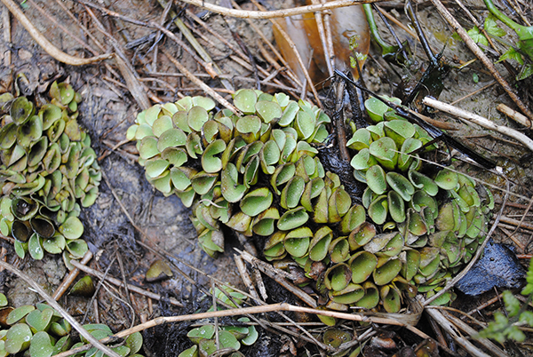
Photo collected… #thenewscompany
Rooted Floating
Ludwigia adscendens (L.) Hara, Ipomoea aquatica Forssk.
Sub-merged
Potamogeton natans L.
Vines, Climbers and Lianas
Pothos scandens L. . Lepistemon binectariferum (Wall.) O. Kuntze. , Ipomoea hederifolia L. . Ipomoea yomae Kurz. Equisetum ramosissimum Desf.
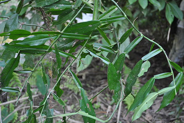
Photo by Bangladesh National Herbarium… #thenewscompany
Epiphytes
Luisia micrantha Hook. f. Hoya parasitica (Roxb.) Wall. ex Wight Drynaria quercifolia (L.) J. Sm. Cymbidium aloifolium (L.) Sw. Cuscuta reflexa Roxb.
Trees
Trewia nudiflora L. Streblus asper Lour. Salix tetrasperma Roxb. Lagerstroemia speciosa (L.) Pers. Hymenodictyon orixensis (Roxb.) Mabb. Gmelia arborea, Ficus racemosa L., . Ficus hispida L. f. Crataeva magna (Lour.) DC.
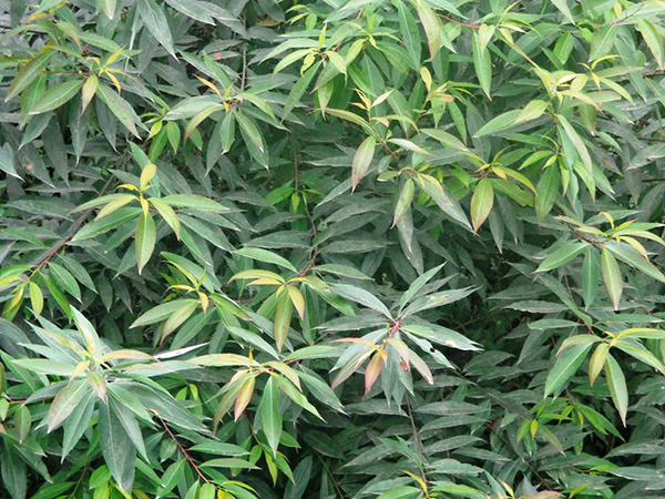
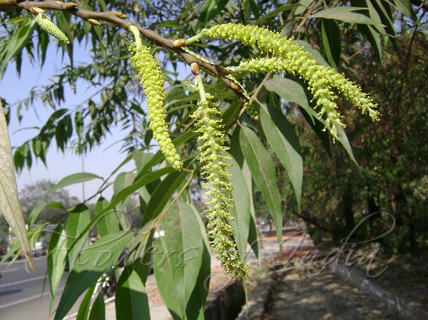
Swamp Indicator species
Indian Willow (Salix tetrasperma ) a rare plant mostly grown in wetlands. It is a widely distributed plant and important constituents of freshwater swamp. This species was found in good abundance 5 decades back in the haor basin swamps in association with Barringtonia, Crateva and Pongamia. But at present the species is an endangered one. It was commonly seen in the pond of lower delta of Bengal. A few trees are found in the floodplains of Ganges and Meghna. During a recent survey, we discovered a good congregation of saplings of Indian Willow in the charlands of the Padma river, where the density is 86 individuals per 10 sq. meter. The highest density recorded in the upstream of the river Karbaphuli at Thegamukh, Gangadhan Chara, Bhusan Chara, Choto Harina and Bara Harina wetlands, In these areas it forms a dense swamp . The density of saplings of this plant at Gangadhanchara is 120 individuals per sq.meter.
But only a few matured trees are seen, because all the natural nurseries are cut down for making land clear to cultivate crops. If protected, this natural regeneration will help re-colonization of this plant into swamp. The wood of this tree are used in making cricket bat and also in holder of spade, knife and other household utensil . The timber is light but very hard and strong. Common English name: Indian Willow • Hindi: Bod, Bains • Manipuri: Ooyum • Bengali: Panijama, Bias, Jal Palash, Panibaj, • Tamil: Atrupalai • Kannada: Niranji • Malayalam: Arali, Atrupala Botanical name: Salix tetrasperma Family: Salicaceae (Willow family)
Medium-sized trees with silky-pubescent branches.Leaves acute or acuminate, serrate along margin.Flowers unisexual, sessile in male, pedicelled or sessile in female, on long catkins.Capsule 2-valved, with persistent bracts.
Indian Willow is a medium sized tree of wet and swampy places, shedding the leaves at the end of monsoon. It flowers after leafing. The bark is rough, with deep, vertical fissures. The young shoots and young leaves are silky. The leaves are lance-like, or ovate-lancelike, 8-15 cm long, with minutely and regularly toothed margins. The male sweet scented catkins are 5-10 cm long, and are borne on leafy branchlets. The female catkins are 8-12 cms long. The capsules are long, stipulate, in groups of 3 to 4. In Manipur, in NE India, the new flowers of Indian Willow, locally known as Ooyum, lightly boiled and mixed with mashed boiled potatoes, and are considered delcicious. Flowering: January-February.
Use – Dried leaves mixed with sugar given in rheumatism, epilepsy, venereal diseases, stone in the bladder, piles and swellings. Bark used as a febrifuge. I had planted this plant in Maluchi, under Shivalaya Upazilla on the bank of canal as an experiment and the result is good which showed that the sapling planted grows well and now it looks like a mini green fence on that area.
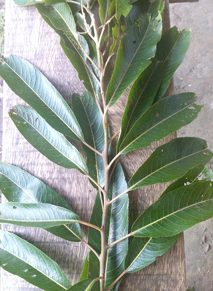
Indian Willow, Photo by Sourav Mahmud
Funal Diversity in the Swamp
Invertebrates
The area supports different types of bees, beetle, spider, butterfly, firefly of them Apis mellifera was the common species among hymenopterans and other invertibrata. Some common genera around the crop fields of the area are: Micraspis, Coccinella, Harmonia, Menochilus, Cheilomenes, and Propylea etc. Firefly is a small, nocturnal, luminescent, carnivorous beetle of the family Lampyridae occurred in haor area. In Bangladesh, the common indoor fly species are the house fly (Musca domestica), the lesser house fly (Fannia canicularis), the biting housefly or stable fly (Stomoxys sp.), the blue bottles or blow flies (Calliphora sp.), the green bottles (Lucilia sp.), and the flesh flies (Sarcophaga sp.). The common genera in our country are Anopheles, Culex, and Aedes. The upland swamp area is no exception of it. These freshwater invertebrates play several important roles in freshwater ecosystem. They are instrumental in cleaning excess living and non-living organic material from freshwater systems, a service that contributes to the overall quality of the freshwater resource. Freshwater mussels filter the water on a microscopic level, removing algae, bacteria, and other micro organisms. Water quality degradation adversely impacts the health of aquatic communities including fish and invertebrates.
-
- Freswater Sponge, Phto by Sufi Atiqur Rahman
-

- Pila
-

- Crabs, Phto by Mr. Sharif Sarwar
The class Crustacea includes the crabs, shrimps, lobsters, barnacles, water fleas, fish lice, hermit crabs, sow bugs, and pill-bugs. Daphnia, Cypris, Cyclops and several copepods are important zooplankter in the freshwaters, and are the food of many fish and other crustaceans.
Some mollusc species mainly Pila, Unio and Bellamya are collected by the local people to feed ducks regularly. Almost every household keep some ducks. Freshwater mussels, Lamellidens spp., are also collected but the amount is negligible. The mollusc shells are used for making slaked lime.
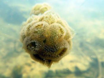
Vertebrates
-

- Notopterous Photo by Sharif Sarwar
-
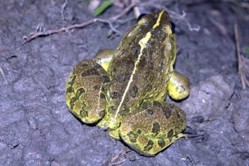
- Bull Frog. Photo by Dr. Lokman Hossain
-
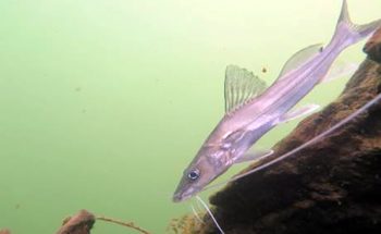
- Cat fish , Guji Photo by Sharif Sarwar
Conclusion
Water in Bangladesh having two faces, one is god gifted natural resources and the other is sorrow. Water in many senses is shaping the national economy by triggering as capital diver of agriculture, fisheries, and transportation sectors. Life and living of the people and their non-human neighbor to a greater extent rely upon on the availability of fresh water. The environment to a greater extent and the life support system is solely bank on the water and its inborn resources. Water scarcity is threatening social and economic growth in rural areas of developing countries. There are potential markets for water purification technologies in these regions. The main focus of this proposal is to evaluate the social, economic and political feasibilities of providing water purification technologies to untapped surface water in rural areas . The findings of this research can serve as the basis for private investors interested in entering this market. Four representative regions were selected for the study. Economic, demographic, and environmental variables of each region will be collected and analyzed along with domestic as well as international markets and political information. Rural areas of the developing world are populated with poor people unable to fulfill the basic needs for clean water and sanitation. These people represent an important group of potential users. Due to economic, social, and political risks in these areas, it is difficult to build a strong case for any business or organization focusing on immediate returns on capital investment. A plausible business strategy would be to approach the water purification market as a corporate responsibility and social investing in the short term. This would allow an organization to be well positioned once the economic ability of individuals, governments, and donor agencies are better aligned.
Freswater swamp is a great reservoir of aquatic biological resources and acts as the ecological safety net to the nature as well as to the dwellers of the haor. But in reality, these areas are considered as wastelands and to make these wastelands into a productive one, a one sided plan has been implementing since long. The water structures which is mainly devoted to increase the monoculture rice production. However, the swamp ecosystem is a multiple-resource base which demands an integrated sustainable development approach for all natural resources. The ongoing management approach to wetlands is biased to only rice production through FCDI and this mode of action and practice in resource use and management of wetlands is diminishing other resources having more economic potential ever thought.
These important resources of the swamp are: grass, submerged plants, reeds, mollusks, fishes, turtles, birds and the swamp forests. Natural gas and peats are two dominant natural energy sources of haor ecosystem. Bio-fuels, Biomass, Bio-energy, Natural manure/bio-compost out of huge aquatic vegetation are totally ignored in the ongoing haor resource management approach.
Clearing of swamp forest and indiscriminate hunting and poaching resulted in extinction of all most all mega fauna including Swamp Deer, Hog Deer, marsh avifauna and trutles and reptiles from the swamp. Eventually mollusk culture, cattle grazing, duck-rearing and winter horticulture might generate huge revenue and local employment. In addition SME in aquatic resources sector could be a new arena of sustainable development for the upland swamp. There is a crisis of visionary philosophy to the upland wetlands resource management. Now, as far as Ramsar convention is concerned, it is an urgent need to change the vision and act as per the modern concept of sustainable development vide the CBD/Ramsar/agenda-21/PRSP and MDGs/SDGs goals and objectives of which Bangladesh is an active partner.
Anisuzzaman Khan
Fellow, Ashoka Innovators for the Public
Acknowledgement
The author is grateful to Mr. Kabir Bin Anwar, Chair, Isabela Foundation and his team “Nodi O Jiboner Sandhane” for providing me this opportunity to discover the rare freswater swam biodiversity. The author is thankful to Ekattor Television for documenting and broadcasting the news of great discovery in their television.
Reference
Bernstein, Alec, “Sustainable Water Management Using Environmental Flows In The Connecticut River” (2013). Environmental &
Water Resources Engineering Masters Projects. 62.
Retrieved from https://scholarworks.umass.edu/cee_ewre/62
Khan, M.A.R. (2014). Wildlife of Bangladesh: Checklist and Guide. Chayabithi Publication, Dhaka. 567 pp.
Khan, M.M.H. (2008). Protected Areas of Bangladesh: A Guide to Wildlife. Bangladesh Forest Department, Dhaka, 304 pp.
MeghnaBabbar-Sebens, Robert C.Barr, Lenore P.Tedesco, MiloAnderson (2018) Spatial identification and optimization of upland wetlands in agricultural watersheds https://www.researchgate.net/publication/257369225


