


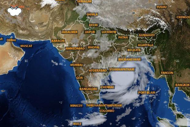
e-News® | The NEWS Company…DHAKA, Oct 11, 2014 – The very severe cyclonic storm “Hudhud” over west central bay and adjoining area moved slightly northwestwards over the same area. It was centred at 6 pm today about 1020 kms west-southwest of Chittagong port, 970 kms west-southwest of Cox’s Bazar port, 870 kms southwest of Mongla port and 880 kms southwest of Payra port, a Met Office weather bulletin said. It is likely to move in a west-northwesterly direction and may cross north Andhra – south Orissa coast of India by forenoon tomorrow.
Maximum sustained wind speed within 74 kms of the storm centre is about 150 kph rising to 170 kph in gusts or squalls. Sea will remain very high near the storm centre. Under the influence of the very severe cyclonic storm, deep convection is taking place over North Bay. Gusty or squally weather may continue over North Bay, coastal area and maritime ports of Bangladesh. Maritime ports of Chittagong, Cox’s Bazar, Mongla and Payra have been advised to keep hoisted local cautionary signal no. three (r) three.
Under the influence of very severe cyclonic storm the low-lying areas of the coastal districts of Cox’s Bazar, Chittagong, Noakhali, Laxmipur, Feni, Chandpur, Borguna, Bhola, Patuakhali, Barisal, Pirozpur, Jhalokathi, Bagherhat, Khulna, Satkhira and their offshore islands and chars are likely to be inundated by wind driven surge of 1-3 feet height above normal astronomical tide.
All fishing boats and trawlers over north bay have been advised to remain in shelter till further notice.


